Infiltration
Infiltration happens when there is still open pore space available. The bigger the grains, the bigger the pore spaces- in this situation, the water moves through faster. On the other hand, the smaller the grain size, the smaller the pore spaces, so the water moves through at a slower rate. Larger grains have a higher permeability. This means that water can travel through it easier. As long as the grain size in each column is uniform, the porosity is the same. This means that there are equal amounts of total pore space in each column.
Factors that assist infiltration:
Factors that assist infiltration:
- unfrozen ground
- flat landscape (low slope)
- pore space
- vegetation
In the animation above, the gravel had the highest permeability, but they all have equal porosity, it just takes a lot longer for the water to get through the clay compared with the others. The clay has a lot of spaces between the grains, it is just that the pores are really tiny!
In the animation below, the first 3 columns have equal porosity and the red beads have the lowest permeability. All the water poured into the first 3 columns comes out the bottom. The 4th column does not allow water to pass through. This is typical when grain size is mixed because the spaces between the large grains are filled with smaller grains. When grains hold onto water and don't let it pass through it is called retention. Because mixed grains have small spaces, they also have the ability to draw water upwards from the bottom, this is called capillarity.
In the animation below, the first 3 columns have equal porosity and the red beads have the lowest permeability. All the water poured into the first 3 columns comes out the bottom. The 4th column does not allow water to pass through. This is typical when grain size is mixed because the spaces between the large grains are filled with smaller grains. When grains hold onto water and don't let it pass through it is called retention. Because mixed grains have small spaces, they also have the ability to draw water upwards from the bottom, this is called capillarity.
What is a landscape?
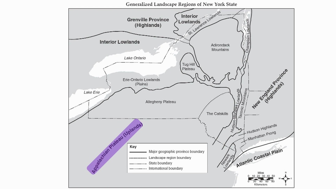
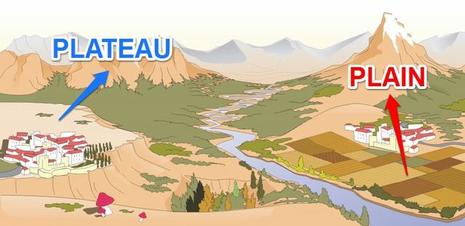
"Landscape regions can usually be identified by the elevation of the region. Mountains, plateaus and plains identify landscape regions. Mountains have high elevation and deformed rock structures due to the great forces that occur when mountains are forming. Plateaus have medium to high elevation. Plains are low in elevation and usually have horizontal rock layers. The boundaries between these 3 distinct areas are generally well defined. Landscape regions tend to be separated by mountains, large bodies of water, and other natural boundaries. The images below is from page 2 and 3 of the ESRT and explain where the 3 different landscape regions can be found in NYS." (Regents Prep)
How do landscapes form?
|
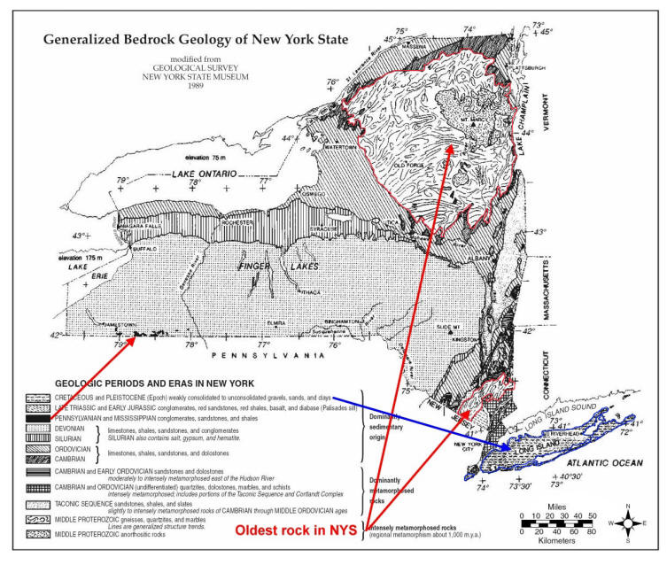
The formation of landscapes depend on the rock underneath the land- this is called the bedrock. Harder rock will be harder to breakdown. There are 2 forces in motion when it comes to determining landscapes. The first is erosion which removes rock from Earth's crust causing elevation to decrease. The second battling force is uplift which is when the crust goes upward causing an increase in elevation. The constant back and forth between erosion and uplift ultimately end in more of one than the other. Think of it like this, if you spend more money then you earn, you are in debt, but if you earn more than you spend, you are saving money. When more uplift than erosion occurs, mountains and plateaus form. When more erosion than uplift occurs, the resulting landscape is a plain or a lowland.
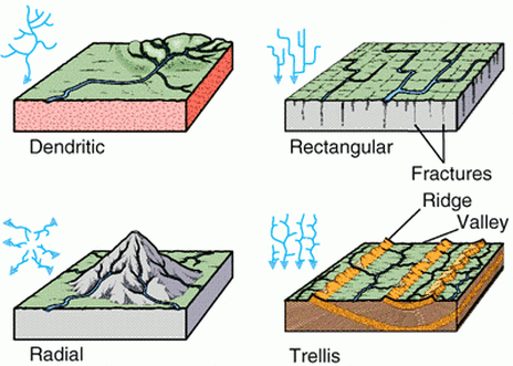
"Climate also plays a large role in the formation of landscapes/ Depending on location areas that are dry (arid) have very little vegetation present with large canyons. An area that is humid will get moderate to high amounts of precipitation. This leads to large amounts of vegetation and well-defined soil profiles. Humid areas are also known for their rounded hills. Bedrock effects how the landscape looks according to its resistance to its resistance to weathering and erosion. Stream drainage patterns are influenced by rock beneath them. There are 4 main types of stream drainage patterns. They are known as DART:
|
|
Weathering & Erosion
Weathering is the process of breaking down rock. It can occur one of 2 ways:
- physical: Using force, roots or ice to crack apart rocks
- chemical: Using oxygen, carbon dioxide or acid to break down rocks
Weathering notes:
|
|
Chemical weathering cave formation:
|
Stream travel notes:
|
Water travels down a stream the same way a car travels down a windy road. It has to slow down to take a sharp turn but can take the outside of the turn faster. When water moves quickly it has the ability to carry bigger sediments. Water travels faster on the outside bend compared to the inside bend. Erosion occurs when water travels quickly and deposition happens when water slows down.
|
Stream erosion and deposition:
|
|
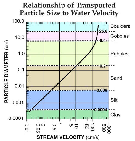
This graph shows the direct relationship between the velocity of a stream and the size of the particles it can transport. The faster the stream flows the larger the particles it can move. On the left is particle diameter, the size in centimeters. The colors show the range of sizes in centimeters.
The colors show the range of sizes that are classified as clay, silt, sand, etc. all the way up to boulders. These size ranges correspond to the values on page 7 for the Grain Size of land-derived sedimentary rocks. Keep this in mind: If a stream is moving fast enough to carry cobbles, it is also carrying everything smaller than cobbles. As it slows down the largest particles drop to the bottom (settle out) first followed by smaller and smaller particles. This is called "sorting" and it can happen vertically or horizontally. regentsearth.com |
|
Deposition
|
When sediments stop being transported and are set down somewhere on Earth's crust, they are said to be deposited. Seen from the chart above, sediments of different sizes are able to stay afloat in different speeds of water. A bigger sediment like a boulder needs very fast moving water whereas something small like clay can stay afloat in very slow moving water. When sediments are set down in water they do it in a particular way. Think of carrying groceries from the car into the house: you bring all the bags at once because you don't want to make 2 trips. As soon as you enter the house you set down the heavy bags (the milk, juice, cans, etc.) The lighter stuff you hold onto for longer and bring it into the kitchen. Rivers and streams do the same thing, as soon as the river meets the ocean it slows down resulting in the deposition of the big particles, like boulders. It then drops off the pebbles, then the sand, silt and finally the clay. This is called sorting and it can look horizontal or vertical depending on the situation.
|
Vertical Sorting and Graded Bedding:
|
Horizontal Sorting:
|
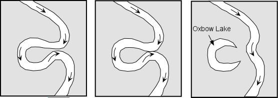
Oxbow lake, small lake located in an abandoned meander loop of a river channel. It is generally formed as a river cuts through a meander neck to shorten its course, causes the old channel to be rapidly blocked off, and then migrates away from the lake. If only one loop is cut off, the lake formed will be crescent shaped, whereas if more than one loop is cut off, the lake will be serpentine or winding. Eventually, oxbow lakes are silted up to form marshes and finally meander scars, marked by different vegetation or the absence of cultivation. The lakes commonly are filled with clay-sized sediment that is less easy to erode than surrounding material and thus may cause a more complex meandering system in its parent stream. (Encyclopedia Britannica)
|
Click below for an animation of oxbow lake formation
|
Glacial Geology
Glacial Features Prezi Notes
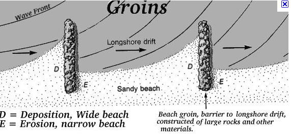
Beach Erosional Features
Barrier islands are natural features that prevent erosion. Waves off the ocean first hit the barrier islands before hitting the main coast of the island. Groins and jetties are manmade structures that prevent sand from eroding and changing the beach coastline.
|
|
