Climate
Climate is the average atmospheric conditions for a location over 20 years or greater.
Climate Factors
Prezi Notes: El Nino, Monsoons
Climate Trends
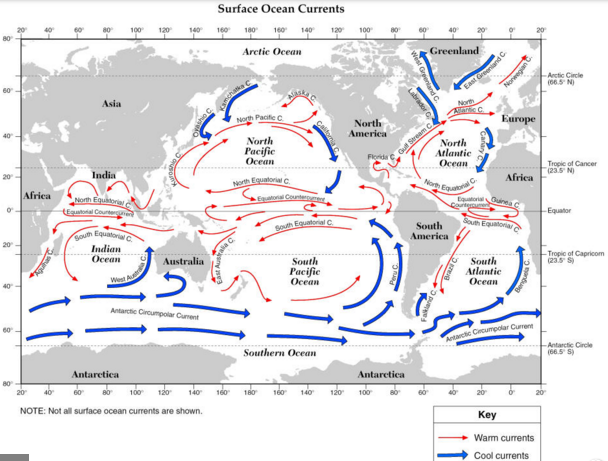
6. Surface Ocean Currents
Surface movement of warm and cold water either towards or away from the equator is driven by the wind. Ocean current temperature plays a big role in an areas climate.
Surface movement of warm and cold water either towards or away from the equator is driven by the wind. Ocean current temperature plays a big role in an areas climate.
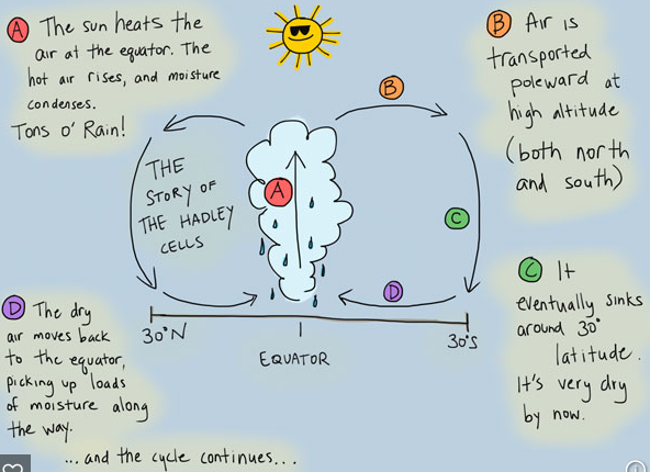
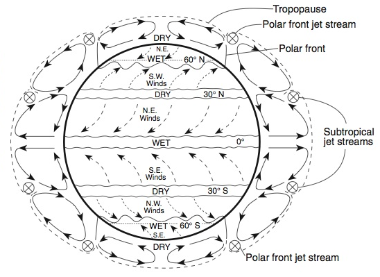
5. Global Winds
These winds effect storm track for latitude zones across the globe.
These winds effect storm track for latitude zones across the globe.
4. Mountain Ranges: Mountain ranges serve as barriers to outbreaks of cold air.
The Sierra Nevada mountains in California demonstrate the rain shadow effect. Warm moist air comes in off the Pacific Ocean and is forced to rise over the mountains. This rising causes cloud formation and rain making land green on the windward side. By the time the air makes its way over the mountain range it is dry and high pressure which causes it to sink and create arid environments on the leeward side.
- Air blown over mountain ranges is forced to rise and cool.
- This causes condensation which forms clouds and precipitation.
- By the time the air reaches the top of the mountain, it has lost much of its moisture.
- When the air descends on the other side of the mountains it is warmed by compression (opposite of expansion).
- The air is warm and dry and precipitation is less likely.
- The side of the mountain that is getting the rising air and rain is called the windward side of the mountain, and the side getting the dry air is called the leeward side.
The Sierra Nevada mountains in California demonstrate the rain shadow effect. Warm moist air comes in off the Pacific Ocean and is forced to rise over the mountains. This rising causes cloud formation and rain making land green on the windward side. By the time the air makes its way over the mountain range it is dry and high pressure which causes it to sink and create arid environments on the leeward side.
3. Local Winds
- Have you ever noticed the constant breeze coming off the ocean during the day time? This is called a sea breeze. This happens because of heating differences between land and water.
- We know that land (soil) is a better absorber and radiator of heat than water. It heats up faster and cools off faster.
- We also know that cold air = high pressure and warm air = low pressure.
- In the day, land gets hotter faster than water, this causes low pressure over the land. The ocean is cooler and therefore the air above it has a high pressure.
- In the night, the water stays warmer than the land (because it gives off heat at a slower rate), this causes low pressure over the water. The land is cooler (because it loses its heat faster) and the air above it is high pressure.
- We know that WIND WILL BLOW FROM HIGH TO LOW
- So in the day we get a breeze from the ocean (higher pressure than air over land)
- and in the night, we get a breeze from the land ... land breeze.
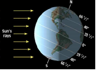
1. Latitude: The main factor that affects a region's temperatures patterns. Latitude determines:
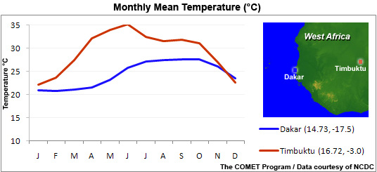
2. Nearness to Large Bodies of Water: Land surfaces heat up and cool off faster than water surfaces. So, air temperatures are usually colder in the winter and warmer in the summer when over land masses than when over oceans at the same latitude. Large bodies of water level out the temperatures of nearby land by warming it in the winter and cooling it in the summer. Therefore, cities near a large body of water tend to have warmer winters and cooler summers than cities far inland.
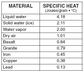
Substances do not all heat up or cool down at the same rate. When heat (measured in joules) is absorbed by substances and does not go through a phase change, the temperature increases. Measuring how fast substances increase in temperature compared to water, gives us this chart called Specific Heats of common Materials.
Any substance that heats up faster than liquid water will have a specific heat value less than 4.18 Joules/gram x C. Any substance that heats up slower will have a value greater than that of liquid water. According to the chart, lead heats up the fastest with the least amount of energy (0.13).
It should be known that materials that take a long time to absorb heat are considered good absorbers. Good absorbers are also good radiators (give off heat well)
- Angle of insolation: the angle that sunlight strikes the Earth's surface
- Duration of insolation: length of day
2. Nearness to Large Bodies of Water: Land surfaces heat up and cool off faster than water surfaces. So, air temperatures are usually colder in the winter and warmer in the summer when over land masses than when over oceans at the same latitude. Large bodies of water level out the temperatures of nearby land by warming it in the winter and cooling it in the summer. Therefore, cities near a large body of water tend to have warmer winters and cooler summers than cities far inland.
Substances do not all heat up or cool down at the same rate. When heat (measured in joules) is absorbed by substances and does not go through a phase change, the temperature increases. Measuring how fast substances increase in temperature compared to water, gives us this chart called Specific Heats of common Materials.
Any substance that heats up faster than liquid water will have a specific heat value less than 4.18 Joules/gram x C. Any substance that heats up slower will have a value greater than that of liquid water. According to the chart, lead heats up the fastest with the least amount of energy (0.13).
It should be known that materials that take a long time to absorb heat are considered good absorbers. Good absorbers are also good radiators (give off heat well)
